

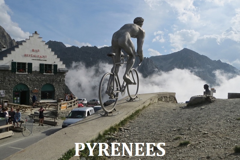
THE PYRENEES
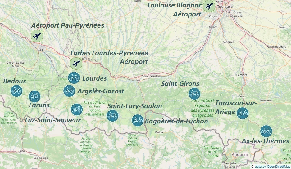

Lourdes: Hautacam, Col du Tourmalet...
Luz-Saint-Sauveur: Col du Tourmalet, Col de Tentes...
Argelès-Gazost: Col de Spandelles, Luz Ardiden...
Saint-Lary-Soulan: Col d'Aspin, Col de Portet...
Laruns: Col d'Aubisque, Col de Marie-Blanque...
Bagnères-de-Luchon: Port de Balès, Col de Peyresourde...
Saint-Girons: Col de Portet d'Aspet, Col d'Agnes...
Tarascon-sur-Ariège: Plateau de Beille, Port de Lers...
Ax-les-Thermes: Ax 3 Domaines, Col de Pailhères...
Bedous: Col de Soudet, Col de Marie-Blanque...
LOURDES
To get to Lourdes the fastest, we can fly to Aéroport de Tarbes-Lourdes-Pyrénées airport by plane; other arrival options (Aéroport Toulouse Blagnac) and information on how to find a cost-effective flight combined with railway and bus transport can be found in the transport section;
Upon arrival, we head to the bus stop where buses of the TL line depart towards Lourdes approximately every hour; the ticket price is 3€, and the timetable, tailored to flight arrivals, can be found on the tlp.aeroport.fr website;
Depending on the chosen accommodation location, we get off at the Gare de Lourdes (train station) or at the next stop - Gare Routière (bus station);
the airport is so close to Lourdes that it is worth considering transportation using known transport companies or taxis, especially if we are traveling in a group of 3-4 people or the chosen accommodation is far from the bus stop;
A map of the Lourdes city bus lines in PDF format can be found here, while the bus schedule can be downloaded to your mobile device from the tlp-mobilites.com website;
We take a bus or taxi to the previously booked accommodation; good places to search for accommodation are reputable services such as airbnb.com and booking.com;
Depending on the time of arrival, before heading to the road bike rental, it is worth taking advantage of the wide range of culinary offerings; the locations of gastronomic points can be found on the mapy.cz website;
If we are not hungry, we do not waste time and head to the most important point of the program...
Bike & Py road bike rental is located at: 16, Esplanade du Paradis, 65100 Lourdes – France and is open from Monday to Sunday from 9 am to 7 pm; it is worth reserving a bike well in advance to ensure that we can rent one upon arrival; the current bike rental prices are available on the above rental website; on the day of arrival and departure, it is also worth planning the route; the rental offers a lower rate for half-day bike rental;
All proposed cycling routes (GPX tracks) from Lourdes start at the Gare de Lourdes train station or after arriving by train at the Lannemezan or Sarrance stations.
If we arrived in Lourdes by car, we need to find a safe parking spot; paid and free parking lots are shown on the
mapy.cz website; the parking lot is also located at the bike rental;
For more information about the town and surrounding areas, visit the Lourdes website.
Hills accessible from Loudres:
1. 100km - Col du Tourmalet: 2115m
2. 93km - Luz Ardiden: 1717m
3. 54km - Col de Tramassel: 1628m
4. 86km - Pont d'Espagne: 1495m
- Cambasque: 1358m
5. 117km - Col d'Aspin: 1489m
- Col du Tourmalet: 2115m
6. 95km - Col de Marie-Blanque: 1035m
- Col d'Aubisque: 1709m
- Col du Soulor: 1474m
7. 100km - Col de Couraduque: 1367m
- Col de Spandelles: 1378m
- Col du Soulor: 1474m


ARGELÈS-GAZOST
To get to Argelès-Gazost the fastest way is by flying to Aéroport de Tarbes-Lourdes-Pyrénées; other arrival options (such as Aéroport Toulouse Blagnac) and information on how to find affordable flights, combined with train and bus transport, can be found in the transport section;
After arrival, we head to the bus stop where buses of the TL line depart towards Lourdes every hour. The ticket price is 3€ and the schedule, adjusted to flight arrivals, can be found on the tlp.aeroport.fr website.
We get off at the Gare Routière (bus station) and transfer to bus line 965, which takes us to Argelès Gazost in 13 minutes, where we can get off at Le Parc; stop. If we want to go to the bike rental first, we get off one stop earlier at Ayzac-Ost - Colline aux Marmottes, which is 300m from the bike rental.
By taxi or on foot, we go straight from the bus stop to our pre-booked accommodation. Good places to look for accommodation are trusted websites such as airbnb.com and booking.com;
Depending on the arrival time, before heading to the bike rental, it's worth taking advantage of the wide range of culinary offerings. In that case, locations of culinary points can be found on the mapy.cz website;
If we're not hungry, we don't waste time and head to the main point of the program...
The road bike rental L'Etape des Pyrénées is located at: 12 avenue des Pyrénées
65400 Argelès Gazost and is open Monday to Saturday 8-12 and 13.30-19 and Sunday 8-12 during the season. Off-season, it's open Monday to Saturday 9-12 and 15-19. It's worth reserving a bike well in advance to be sure to rent one upon arrival. Current bike rental prices are on the aforementioned rental website. On the day of arrival and departure, it's also worth planning the route;
All cycling route suggestions (gpx tracks) from the town of Argelès-Gazost start at the parking lot at Place du Foirail.
If we arrive in Argelès-Gazost by car, we need to find a safe parking spot. Paid and free parking spots are shown on the
mapy.cz website; There's also a parking lot near the bike rental;
For more information about the town and surrounding areas, visit the Argelès-Gazost website;
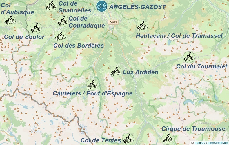
Hills accessible from Argelès-Gazost:
1. 67km - Col des Bordères: 1156m
- Col du Soulor: 1474m
- Col d'Aubisque: 1709m
2. 36km - Col de Tramassel: 1628m
3. 97km - Col de Tentes: 2208m
4. 60km - Pont d'Espagne: 1495m
- Cambasque: 1358m
5. 43km - Col de Couraduque: 1367m
- Col des Bordères: 1156m
6. 101km - Col du Tourmalet: 2115m
7. 65km - Col de Spandelles: 1378m
- Col du Soulor: 1474m
- Col des Bordères: 1156m
8. 97km - Cirque de Troumouse: 2088m
- Lac des Gloriettes: 1697m
9. 63km - Luz Ardiden: 1717m


LUZ-SAINT-SAUVEUR
To get to Luz-Saint-Sauveur the quickest way is by flying to Aéroport de Tarbes-Lourdes-Pyrénées; Other arrival options (such as Aéroport Toulouse Blagnac) and information on finding affordable flights connected with rail and bus transport can be found in the transport section;
After arrival, we head to the bus stop, from which the TL line buses depart every hour towards Lourdes. The ticket price is 3€ and the timetable, adapted to flight arrivals, can be found on the tlp.aeroport.fr website;
We get off at the Gare Routière (bus station) and transfer to the 965 bus line, which takes us directly or with a transfer in Argelès Gazost the Place 8 Mai 1945, in Luz-Saint-Sauveur - from both bike rental shops. Buses only run four times a day (more details on the "Transport" section) and very rarely directly from the airport. The 2023 timetable in PDF format is available here;
We can reach our pre-booked accommodation by taxi or on foot straight from the bus stop. Good places to look for accommodation are trusted websites such as airbnb.com and booking.com.
If we want to take advantage of the gastronomic offer, we can find the locations of gastronomic points on the mapy.cz website;
If we are not hungry, we don't waste time and head to the most important point of the program...
Road bike rentals:
- Ardiden Velos is located at: 3, Place 8 mai, Luz-Saint-Sauveur i w sezonie jest czynna od poniedziałku do niedzieli od 8.00 - 19.30;
- Tourmalet - Bikes is located at: 18 Place du 8 mai, 65120 Luz St Sauveur
It's worth reserving a bike well in advance to ensure bike rental upon arrival. Current bike rental prices can be found on the above rental websites. On the day of arrival and departure, it's also worth planning the route.
All cycling route proposals (gpx tracks) from the town of Luz-Saint-Sauveur start at the parking lot at Place 8 Mai.
If we arrive in Luz-Saint-Sauveur by car, we need to find a safe parking spot. Paid and free parking lots are shown on the
mapy.cz website. Parking is also available near the bike rental shops.
More information about the town and its surroundings can be found on the Luz-Saint-Sauveur website;
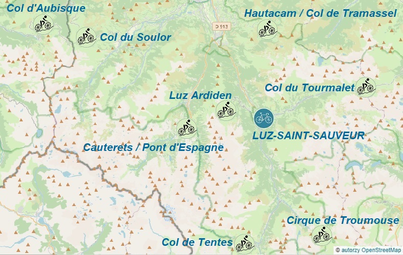
Hills accessible from Luz-Saint-Sauveur:
1. 60km - Cirque de Troumouse: 2088m
- Lac des Gloriettes: 1697m
2. 37km - Col du Tourmalet: 2115m
3. 100km - Col du Tourmalet: 2115m
- Col de la Croix Blanche: 820m
4. 71km - Pont d'Espagne: 1495m
- Cambasque: 1358m
5. 33km - Luz Ardiden: 1717m
6. 64km - Col de Tramassel: 1628m
7. 92km - Col du Soulor: 1474m
- Col d'Aubisque: 1709m
8. 60km - Col de Tentes: 2208m


LARUNS
To get to Laruns the fastest way is by flying to Aéroport Pau Pyrénées; other arrival options (Tarbes-Lourdes-Pyrénées Airport or Toulouse Blagnac Airport) and information on how to find a favorable flight combined with rail and bus transportation can be found in the transport section;
Upon arrival at Pau airport, if we decide to take a taxi (beneficial for 3-4 people), the cost to the center of Pau will be around €32;
if we decide to take the bus, we go to the IDELIS bus stop - on the right-hand side after exiting the terminal building, from where buses of line 10 depart for the center of Pau every hour (they do not run on Sundays and holidays); the bus ride takes about 30 minutes and we buy the ticket from the driver; the one-way cost is €1.30; the 2022 timetable is available in PDF file; we get off at the Pau-Bosquet Quai F stop and walk from this stop, the line 524 bus to Laruns runs twice a day; the timetable can be found on the Pau public transport website: idelis.fr; we get off in the center of Laruns at Maison aux 5 Sens stop;
We go straight to our pre-booked accommodation from the bus stop; good places to search for accommodation are trusted services such as airbnb.com and booking.com.
If we want to take advantage of the gastronomic offer, we can find the locations of gastronomic points on the mapy.cz website;
if we are not hungry, we do not waste time and head to the most important point of the program...
The road bike rental: Locaski is located at Av. de la Gare, 64440 Laruns, France; check it out on Google StreetView;
it is worth booking a bike well in advance to ensure that we can rent a bike upon arrival; current bike rental prices are available on the above rental website.
If we arrive in Laruns by car, we must find a safe parking spot; paid and free parking spots are shown on the mapy.cz website;
Below are some excursion proposals from the town of Laruns - all GPX tracks start at the parking lot near the bike rental at the intersection of Rue du Gourzy and Avenue de la Gare.
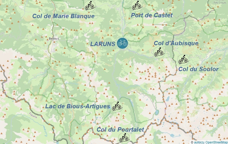
Hills accessible from Luruns:
1. 68km - Col du Pourtalet: 1794m
- Lac de Bious-Artigues: 1428m
2. 56km - Col d'Aubisque: 1709m
- Col du Soulor: 1474m
3. 76km - Port de Castet: 870m
- Col de Marie-Blanque: 1035m


SAINT-LARY-SOULAN
To reach Saint-Lary-Soulan quickly, the fastest way is to fly to Aéroport de Tarbes-Lourdes-Pyrénées; Other arrival options (such as Aéroport Toulouse Blagnac) and information on how to find affordable flights combined with rail and bus transport can be found in the transport section;
Upon arrival, head to the bus stop where buses of line T7 depart approximately every hour towards Tarbes. The ticket price is 3€, and the schedule is adjusted to match the flight arrivals and can be found on the tlp.aeroport.fr website; Get off at the last stop at Gare de Tarbes (train station).
After a 25-minute ride on a regional train, we reach the Gare de Lannemezan railway station. Here, we switch to bus line 963, which takes us directly to Saint-Lary-Soulan. The journey takes 1 hour and 10 minutes, and the schedule can be found on the saintlary.com or mestrajets.lio.laregion.fr website; Get off at the Saint-Lary-Soulan Ardoune stop;
From the bus stop, we go straight to the previously booked accommodation. Good places to look for accommodation are trusted services such as airbnb.com and booking.com.
If we want to take advantage of the gastronomic offer, we can find the locations of gastronomic points on the mapy.cz website;
If we are not hungry, we don't waste time and head straight to the most important point of the program...
Evolution 2 bike rental is located: 15 rue Vincent Mir 65170 Saint Lary Soulan and is open from Monday to Sunday during the season from 9.00 - 13.00 and from 14.00 - 19.00; It is worth reserving a bike well in advance to ensure availability upon arrival. Current bike rental prices can be found on the above-mentioned rental websites.
f we arrive in Saint-Lary-Soulan by car, we must find a safe parking spot. Paid and free parking areas are shown on the mapy.cz website;
Below are suggested trips from the town of Saint-Lary-Soulan - all GPX tracks start at ARRÊT OUIBUS Parking du Stade, located opposite the Club Olympique St Lary Rugby pitch.;
For more information about the town and its surroundings, visit the saintlary.com website;
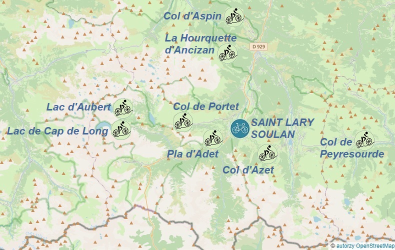
Hills accessible from Saint-Lary-Soulan:
1. 65km - Col d'Azet: 1580m
- Col de Peyresourde: 1569m
2. 55km - Col d'Aspin: 1489m
- La Hourquette d'Ancizan: 1564m
3. 60km - Lac de Cap de Long: 2172m
- Lac d'Aubert: 2167m
4. 41km - Col de Portet: 2211m
- Pla d'Adet: 1653m


BAGNÈRES-DE-LUCHON
To get to Bagnères-de-Luchon the quickest way is by flying to Aéroport de Tarbes-Lourdes-Pyrénées; information on finding a favorable flight connected with rail and bus transport can be found in the transport transport section;
After arrival, we head to the bus stop, where T7 buses depart towards Tarbes approximately every hour. The ticket price is €3 and the timetable, tailored to flight arrivals, can be found on the tlp.aeroport.fr website; We get off at the last stop at Gare de Tarbes (train station).
By regional train, we arrive at Gare de Montréjeau - Gourdan-Polignan train station after 37 minutes. Here we change to a coach belonging to the SNCF railway network, which takes us directly to Bagnères-de-Luchon. The journey takes 48 minutes, and there are six trips daily. The timetable can be found on the French railway website: sncf.com; We get off in centrum of Bagnères-de-Luchon, near the bike rental shop.
Straight from the bus stop, we reach the previously booked accommodation. Good places to look for lodging are trusted services such as airbnb.com and booking.com.
If we want to take advantage of the gastronomic offer, we can find the locations of culinary points on the mapy.cz website;
If we are not hungry, we do not waste time and head to the most important part of the program...
Luchon Mountain Bike road bike rental is located at: 4, Place du Comminges 31110 Bagnères de Luchon; it is worth booking a bike well in advance to ensure bike rental upon arrival. Current bike rental prices and opening hours can be found on the rental website.
If we arrived in Bagnères de Luchon by car, we must find a safe parking spot; paid and free parking lots are shown on the mapy.cz website;
Below are some suggestions for trips from the town of Bagnères-de-Luchon - all gpx trails start at Place Léo Lagrange, located 150m from the bike rental shop.
More information about the town and surrounding areas can be found on the mairie-luchon.fr website;

Hills accessible from Bagnères-de-Luchon:
1. 38km - Port de Balès: 1755m
2. 50km - Superbagnéres: 1798m
- Hospice de France: 1385m
3. 78km - Col du Portillon: 1293m
- Col de Menté: 1349m
4. 68km - Port de Balès: 1755m
5. 84km - Col de Peyresourde: 1569m
- Col d’Azet: 1580m


SAINT-GIRONS
To get to Saint-Girons the fastest way is by flying to Aéroport Toulouse Blagnac; information on how to find a convenient flight connected with rail and bus transportation can be found in the transport section;
After arrival, we head to the tram stop where tram line T2 departs every 20 minutes towards Toulouse; the ticket price is €1.7 and the journey takes 35 minutes; we get off at the Palais de Justice stop and walk for 3 minutes (170m) to the Toulouse - Chaussée bus stop, where we take bus line 452 directly to Saint Girons.
The journey takes 2h05min and there is one daily service at 15:55 (as of October 2022); we get off at the Saint-Girons - Place Des Capots stop in the city center;
We head straight from the bus stop to our pre-booked accommodation; good places to search for accommodation are trusted websites such as airbnb.com and booking.com.
If we want to take advantage of the gastronomic offer, we can find the locations of restaurants on the mapy.cz website;
if we're not hungry, we don't waste time and head straight to the main point of our program...
Cycle & Vous road bike rental is located at: 28 Rue Villefranche 09200 Saint-Girons and is open during the season from Monday to Saturday from 09:00-12:00 and from 14:00-19:00; it's worth booking a bike well in advance to ensure availability upon arrival.
If we arrive in Saint-Girons by car, we must find a safe parking spot; paid and free parking options are shown on the mapy.cz website;
Below are suggested trips from Saint-Girons - all gpx trails start at the parking lot at Av. du Maréchal Foch, located 300m from the bike rental shop.
For more information about the city and surroundings, visit the ville-st-girons.fr website;
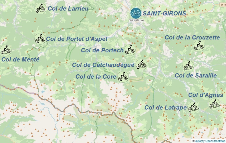
Hills accessible from Saint-Girons:
1. 65km - Col de la Core: 1395m
- Col de Catchaudégué: 893m
- Col de Portech: 862m
2. 107km - Col de Larrieu: 704m
- Col de Menté: 1349m
- Col de Portet d'Aspet: 1069m
3. 96km - Col de Latrape: 1110m
- Col d'Agnes: 1570m
4. 63km - Col de la Crouzette: 1245m
- Col de Saraille: 942m


AX-LES-THERMES
To reach Ax-les-Thermes the quickest way is by flying to Aéroport Toulouse Blagnac; information on how to find a convenient flight combined with railway and bus transportation can be found under the transport section;
Upon arrival, we head to the bus stop where the AERO line buses depart every 20 minutes towards the Toulouse Matabiau railway station; the ticket costs 2€ and the journey takes 22 minutes; we get off at the Matabiau Gare SNCF stop and walk for 3 minutes (150m) to the Gare de Toulouse Matabiau railway station, where we take a direct regional train to Ax-les-Thermes.
The train runs every 1-2 hours, the journey takes 1h51min, and the ticket costs 10-22€.
Straight from the railway station, we arrive at our previously reserved accommodation; good places to search for lodging are trusted services such as airbnb.com and booking.com.
If we want to enjoy the local gastronomy, we can find the locations of food points on the mapy.cz website;
if we are not hungry, we can proceed to the most important point of our trip...
Ax Sports Loisirs road bike rental is located at:
29 C La Gare 09110 Ax-les-Thermes - 300m from the Ax-les-Thermes railway station; it is worth reserving a bike well in advance to ensure availability upon arrival.
If we arrive in Ax-les-Thermes by car, we need to find a safe parking spot; paid and free parking areas are shown on the mapy.cz website;
Below are some suggested trips from the town of Ax-les-Thermes - all GPX trails start at the Gare de Ax-les-Thermes railway station, located 300m from the bike rental.
For more information on the town and its surroundings, visit the ariegepyrenees.com website;
Hills accessible from Ax-les-Thermes:
1. 46km - Col du Chioula: 1432m
- Ax 3 Domaines: 1381m
2. 94km - Carrière de Trimouns: 1535m
- Plateau de Beille: 1785m
3. 59km - Col du Pradel: 1680m
- Col des Sept Frères: 1253m
- Col du Chioula: 1432m
4. 83km - Col de Pailhères: 2001m
- Col du Pradel: 1680m


TARASCON-SUR-ARIÈGE
o get to Tarascon-sur-Ariège the fastest way, we can fly to Aéroport Toulouse Blagnac; information on how to find a convenient flight connected with railway and bus transport can be found in the transport section;
After arrival, we go to the bus stop where AERO buses depart every 20 minutes towards the Gare de Toulouse Matabiau railway station; the ticket price is 2€ and the journey takes 22 minutes; we get off at the Matabiau Gare SNCF stop and walkfor 3 minutes (150m), we go to the Gare de Toulouse Matabiau railway station where we take a direct regional train to Tarascon-sur-Ariège.
The train runs every 1-2 hours, the journey takes 1h26min and the ticket costs 10-18€.
Straight from the train station, we reach the previously booked accommodation; good places to look for accommodation are trusted websites such as airbnb.com and booking.com.
If we want to take advantage of the culinary offer, the locations of gastronomic points can be found on the mapy.cz website;
if we are not hungry, we don't waste time and head to the most important point of the program...
Point Glisse road bike rental is located at:
7 Avenue Saint-Roch 09400 Tarascon-sur-Ariège - 930m from the Gare de Tarascon-sur-Ariège train station; it is worth booking a bike well in advance to ensure bike rental upon arrival.
If we arrive in Tarascon-sur-Ariège by car, we must find a safe parking spot; paid and free parking spots are shown on the mapy.cz website;
Below are suggestions for trips from the town of Tarascon-sur-Ariège - all GPX traces start at the Gare de Tarascon-sur-Ariège train station or after arriving by train at the Foix and Ax-Les-Thermes stations.
For more information about the town and surroundings, visit ariegepyrenees.com;
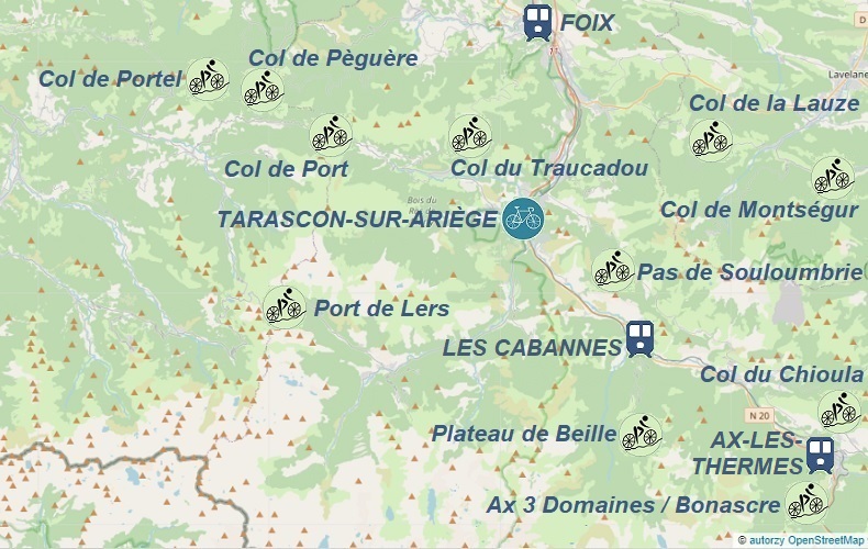
Hills accessible from Tarascon-sur-Ariège:
1. 75km - Col de Port: 1249m
- Port de Lers: 1517m
2. 78km - Col de Portel: 1432m
- Col de Port: 1249m
3. 92km - Col du Traucadou: 1324m
- Col de Port: 1249m
- Col de Pèguère: 1379m
4. 52km - Plateau de Beille: 1785m
- Pas de Souloumbrie: 911m
5. 114km - Ax 3 Domaines: 1381m
- Col du Chioula: 1432m
- Col de Montségur: 1059m
- Col de la Lauze: 948m


BEDOUS
To get to Bedous the quickest, you can fly into either Aéroport Pau Pyrénées or Aéroport de Tarbes-Lourdes-Pyrénées; information on finding a convenient flight combined with train and bus transportation can be found under the transport section;
One of the many ways to get to Bedous efficiently is as follows:
upon arrival, go to the bus stop where buses of the TL line depart for Lourdes approximately every hour. The ticket price is 3€ and the schedule, adjusted to the flight arrivals, can be found on the tlp.aeroport.fr website;
Get off at the Gare de Lourdes (train station) and transfer to a train heading towards Bedous. Trains depart 3 times a day with 1 transfer in Pau.
From the train station, head to your pre-booked accommodation. Good places to look for accommodation are trusted services like airbnb.com and booking.com.
If you're interested in the local cuisine, you can find locations of dining establishments on the mapy.cz website;
If you're not hungry, head straight to the most important part of your itinerary...
Cycl'On road bike rental is located a Pl. François Sarraille, 64490 Bedous, France;
It's worth reserving a bike well in advance to ensure availability upon arrival.
If you're driving to Bedous, you'll need to find a safe parking spot. Paid and free parking spots are shown on the mapy.cz website;
Below are some suggested tours starting from Bedous, all of which start at the Gare de Bedous train station.
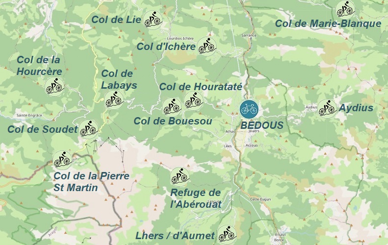
Hills accessible from Bedous:
1. 87km - Col de Bouesou: 1009m
- Col de la Hourcère: 1440m
- Col de Soudet: 1540m
- Col de Lie: 601m
2. 77km - Col de Hourataté: 1009m
- Col de la Pierre St Martin: 1802m
- Col de Soudet: 1540m
- Col de Labays: 1351m
- Col de Lie: 601m
- Col d'Ichère: 674m
3. 60km - Col de Marie-Blanque: 1035m
- Aydius: 849m
4. 54km - Refuge de l'Abérouat: 1439m
- Lhers / d'Aumet: 1169m


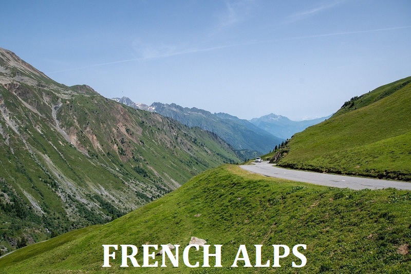
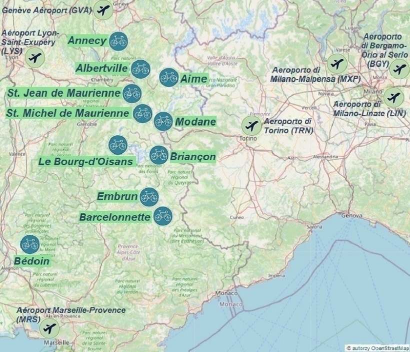
FRENCH ALPS
Cycling routes by starting location:
To all the starting locations, you can drive with your own bike.
If you decide to use public transport, you will find some information on the following pages:
The nearest airports to all the routes in the French Alps are Aéroport Lyon-Saint-Exupéry, Aéroport Marseille-Provence, Genève Aéroport or Aeroporto di Torino;
The choice of airport depends on where and on what day of the week we want to arrive;
Details and proposals for connections from airports to the "starting" towns can be found on the following pages describing each town, which we can choose from the map below by clicking on the bike icon.
Proposals for air connections to Marseille, Lyon, Genève, and Turin can be found in the transport section.


BRIANÇON
The quickest way to get to Briançon is by flying to Aéroport Lyon-Saint-Exupéry, Aéroport Marseille-Provence or Aeroporto di Torino; Information on how to find a convenient flight combined with rail and bus transport can be found under the transport section;
One of the many ways to reach Briançon is:
After arriving at Aéroport Marseille-Provence go to the bus stop where buses of L40 line depart approximately every 30 minutes towards Gare Routière de Aix-en-Provence (the journey takes about 30 minutes). The ticket costs 10€, and the timetable can be found on the airport's website in PDF format. Tickets can be purchased online;
Get off at the last stop Aix-en-Provence - Gare Routière and walk for 8 minutes (500m) to the train station. From there, take a direct train from Gare de Aix-en-Provence to Briançon (important not to confuse Gare de Aix-en-Provence with Aix-en-Provence TGV station, which is earlier).
Direct trains to Briançon depart three times a day (updated information under the "Transport" tab): at 8:25, 13:54, and 17:24. The journey takes from 3 hours 42 minutes to 4 hours, and tickets can be purchased at sncf-connect.com;
Get off at Gare de Briançon station;
Information about public transport in Briançon can be found on ville-briancon.fr;
A map of urban bus lines in Briançon is available tutaj;
After arriving in Briançon by train or bus, transfer to a taxi or public transport (information above) and reach the previously booked accommodation. Good places to search for accommodation are trusted websites such as airbnb.com and booking.com.
If we want to take advantage of the gastronomic offer, we can find the locations of gastronomic points on mapy.cz;
If we are not hungry, we do not waste time and head to the most important point of the program...
Road bike rentals:
- Roue Libre Briançon is located at: 24 Av. du 159E Ria, 05100 Briançon;
- Francis SPORTS is located at: 7 Av. René Froger, 05100 Briançon;
- Mountain Cycles is located at: Espace Sud 342 Rue du Marechal de Lattre de Tassigny, 05100 Briançon;
It is worth booking a bike well in advance to ensure its availability upon arrival. Current rental prices are available on the rental websites mentioned above. It is also worth planning the route on the day of arrival and departure.
All proposed cycling routes (GPX tracks) starting from the town of Briançon begin at Gare de Briançon train station or after arriving by train at 'Gare de Mont-Dauphin - Guillestre' station.
If we arrive in Briançon by car, we need to find a safe parking space. Paid and free parking spaces are shown on the
mapy.cz website and there is also parking available near bike rentals.
For more information about the town and its surroundings, please visit the Briançon website;
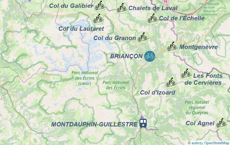
Hills accessible from Briançon:
1. 64km - Col d'Izoard: 2360m
- Les Fonts de Cervières: 2040m
2. 74km - Col du Lautaret: 2057m
- Col du Galibier: 2642m
3. 105km - Col Agnel: 2744m
- Col d'Izoard: 2360m
4. 35km - Col du Granon: 2413m
5. 83km - Montgenèvre: 1860m
- Col de l'Échelle: 1762m
- Chalets de Laval: 2022m


LE BOURG D'OISANS
To reach Le Bourg-d'Oisans quickly, the best option is to fly to Aéroport Lyon-Saint-Exupéry; information on finding a convenient flight combined with bus transportation can be found under the transport section;
One of the many options to reach Le Bourg-d'Oisans is:
After arriving at Lyon-Saint-Exupéry Airport, go to the bus stop where Flixbus departs every hour towards Grenoble (the journey takes one hour); the ticket price starts at 14€, and the schedule and ticket purchase options can be found on the Flixbus website;
Get off at the Gare Routière stop in Grenoble and transfer to bus T75, which departs several times a day to Le Bourg-d'Oisans; get off at the Office de Tourisme stop or another stop that suits you; the schedule is available here;
Upon arrival in Le Bourg-d'Oisans, go to your previously booked accommodation. Good places to look for accommodations are verified services such as airbnb.com and booking.com;
If you want to take advantage of the gastronomic offer, you can find the locations of food establishments on the mapy.cz website;
If you're not hungry, don't waste time and head to the most important point of the program...
Road bike rental:
- Cycles et Sports is located at: Avenue Docteur Louis Faure 114-118, 38520 Le Bourg-d'Oisans;
It is worth reserving a bike well in advance to ensure that a bike is available upon arrival. The current bike rental prices can be found on the rental company's website.
All proposed cycling routes (GPX tracks) from Le Bourg-d'Oisans start at the parking lot of the bike rental.
If you arrived in Le Bourg-d'Oisans by car, you must find a safe parking spot; paid and free parking spots are shown on the mapy.cz website;
For more information about the town and its surroundings, please visit the Le Bourg-d'Oisans website;
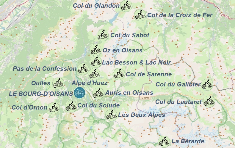
Hills accessible from Le Bourg-d'Oisans:
1. 60km - Alpe d'Huez: 1840m
- Lac Besson & Lac Noir: 2083m
- Col de Sarenne: 1999m
2. 57km - Col du Solude: 1680m
- Col d'Ornon: 1371m
- Oulles: 1406m
3. 62km - Auris en Oisans: 1563m
- Les Deux Alpes: 1660m
4. 65km - La Bérarde: 1708m
5. 83km - Col du Sabot: 2100m
- Oz en Oisans: 1360m
- Pas de la Confession: 1542m
6. 95km - Col du Lautaret: 2057m
- Col du Galibier: 2642m
7. 77km - Col du Glandon: 1924m
- Col de la Croix de Fer: 2068m


MODANE
To get to Modane the fastest way, you can fly to Aéroport Lyon-Saint-Exupéry or Aeroporto di Torino;
Information on how to find a convenient flight connected with bus transportation can be found in the transport section;
One of the many ways to get to Modane is to fly to Aéroport Lyon-Saint-Exupéry go to the Lyon-Saint-Exupéry TGV railway station, take a train to Lyon city center, and then take a direct train to Modane. The entire journey takes about 3 hours and 30 minutes.
Another option is to take a Flixbus directly from the airport to Chambéry, and then switch to a train to Modane.
Once you arrive in Modane by train, you can take a taxi, bus, or walk to your pre-booked accommodation. Good places to look for lodging are trusted services such as airbnb.com and booking.com;
If you want to explore the culinary offerings in Modane, you can find the locations of dining establishments on mapy.cz;
If you're not hungry, you can head straight to the most important point of the program...
A road bike rental Action Sports is located at: Rue de la République 7, 73500 Modane;
It is advisable to book a bike well in advance to ensure availability upon arrival. The current bike rental prices can be found on the rental company's website.
All proposed cycling routes (GPX tracks) from the town of Modane begin at the train station, which is located 300m from the bike rental or at the Gare de Saint-Michel - Valloire station after arriving by train;
If you arrive in Modane by car, you will need to find a safe parking spot. Paid and free parking options are shown on the mapy.cz website;
For more information about Modane and its surroundings, visit the official Modane website;
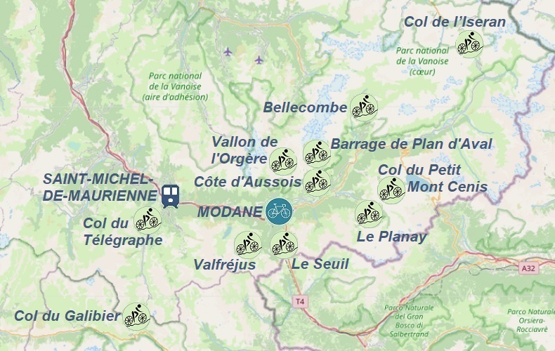
Hills accessible from Modane:
1. 114km - Col de l’Iseran: 2770m
2. 87km - Col du Télégraphe: 1566m
- Col du Galibier: 2642m
3. 96km - Côte d'Aussois: 1519m
- Col du Petit Mont Cenis: 2184m
4. 95km - Barrage de Plan d'Aval: 2016m
- Bellecombe: 2313m
- Le Planay: 1661m
5. 61km - Vallon de l'Orgère: 1923m
- Valfréjus: 1550m
- Le Seuil: 1984m


SAINT-MICHEL-DE-MAURIENNE
To reach Saint-Michel-de-Maurienne as quickly as possible, we can fly to either Aéroport Lyon-Saint-Exupéry or Aeroporto di Torino;
information on how to find a favorable flight combined with bus transport can be found in the transport section;
jOne of the many options for getting to Saint-Michel-de-Maurienne is to fly to Aéroport Lyon-Saint-Exupéry then take a train from Lyon-Saint-Exupéry TGV station to Lyon city center and then directly to Saint-Michel-de-Maurienne by train; the whole journey takes about 3 hours and 30 minutes.
Another option is to take a Flixbus directly from the airport to Chambéry, where we can then transfer to a train to Saint-Michel-de-Maurienne.
Upon arrival in Saint-Michel-de-Maurienne by train, we can transfer to a taxi or walk to the pre-booked accommodation; good places to search for accommodation are verified services such as airbnb.com and booking.com;
If we want to enjoy the local gastronomic offerings, we can find the locations of restaurants on the mapy.cz website;
If you're not hungry, you can head straight to the most important point of the program...
Le Marché du Vélo a road bike rental shop, is located at: 54 rue du Général Ferrié 73140 St Michel De Maurienne;
bikes must be reserved at least 5 days in advance through rentmybike.fr, choosing the pickup location as Maurienne; current rental prices are available during the booking process;
All proposed cycling routes (gpx tracks) from Saint-Michel-de-Maurienne start at the Gare de Saint-Michel - Valloire train station, which is 200m from the bike rental shop, or at the 'Gare de Saint-Avre - La Chambre' station after arriving by train.
If we are driving to Saint-Michel-de-Maurienne, we must find a safe parking spot; paid and free parking locations are shown on the mapy.cz website;
Hills accessible from Saint-Michel-de-Maurienne:
1. 71km - Col du Télégraphe: 1566m
- Col du Galibier: 2642m
2. 69km - Le Pérousaz: 1606m
- Charbutin: 1464m
- Montdenis / Les Villes: 1504m
3. 35km - Valmeinier 1800: 1854m
4. 48km - Col d'Albanne: 1656m
5. 76km - Col du Glandon: 1924m
- Col de la Croix de Fer: 2067m
- Col du Mollard: 1638m


SAINT-JEAN-DE-MAURIENNE
To get to Saint-Jean-de-Maurienne the fastest way is by flying to Aéroport Lyon-Saint-Exupéry;
information on finding a favorable flight combined with bus transportation can be found in the transport section;
One of the many options for getting to Le Bourg-d'Oisans is:
After arriving at Lyon-Saint-Exupéry Airport, go to the train station and take a train to Lyon city center and then to Saint-Jean-de-Maurienne; the whole journey takes about 3 hours and 30 minutes.
Another option is to take a Flixbus directly from the airport to Chambéry and then change to a train to Saint-Jean-de-Maurienne.
Upon arriving in Saint-Jean-de-Maurienne by train, take a taxi or walk to the pre-booked accommodation; trusted accommodation websites include airbnb.com and booking.com;
If you want to take advantage of the culinary offerings, you can find the locations of gastronomic points on the mapy.cz website;
if you're not hungry, don't waste time and head straight to the main event...
Road bike rental:
- dVélos is located at: Rue de la Libération 249, 73300 Saint-Jean-de-Maurienne;
it's worth reserving a bike well in advance to ensure availability upon arrival; current rental prices can be found on the rental website;
All proposed cycling routes (GPX tracks) from the town of Saint-Jean-de-Maurienne start at the Gare de Saint-Jean-de-Maurienne Arvan train station, which is 900m from the bike rental.
If you arrive in Saint-Jean-de-Maurienne by car, you'll need to find a safe parking spot; paid and free parking options can be found on the mapy.cz website and there is also parking near the bike rental.
Hills accessible from Saint-Jean-de-Maurienne:
1. 63km - Col du Glandon: 1924m
- Col de la Croix de Fer: 2067m
2. 99km - Col du Télégraphe: 1566m
- Col du Galibier: 2642m
3. 78km - Col du Chaussy: 1533m
- Col de la Madeleine: 2000m
4. 70km - Col du Sapey: 1306m
- Montdenis / Les Villes: 1504m
- Col d'Albanne: 1656m


AIME
To get to Aime as quickly as possible, the best way is to fly to either Aéroport Lyon-Saint-Exupéry or Genève Aéroport (GVA);
information on how to find a convenient flight combined with bus transportation can be found in the transport section;
One of the many convenient ways to get to Aime is to take a Flixbus (around 20€) from the bus stop at Lyon-Saint-Exupéry Airport to Chambéry and then transfer to a regional train to Aime-La Plagne; the ticket price is usually 12€ and the schedule and ticket purchasing options can be found on the SNCF carrier's website.
Upon arrival in Aime by train, you can either take a taxi or walk to your previously booked accommodation; good places to look for accommodation include trusted services such as airbnb.com and booking.com;
If you're interested in dining options, you can find the locations of gastronomic points on the mapy.cz website;
if you're not hungry, don't waste time and head straight to the main attraction...
Bike Surgery road bike rental shop is located at: 8 place Joux, 73210 Aime;
it's worth reserving a bike well in advance to ensure availability upon arrival; current bike rental prices can be found on the rental company's website.
All proposed cycling routes (GPX tracks) from Aime begin at the Aime-La Plagne train station or after arriving by train at the Bourg-Saint-Maurice, Moûtiers, Notre-Dame de Briançon, or Albertville train stations.
If you arrive in Aime by car, you will need to find a safe parking spot; paid and free parking options are shown on the mapy.cz website; parking is also available near the bike rental shop;
Hills accessible from Aime:
1. 42km - La Plagne Aime 2000: 2090m
2. 37km - Plan-Pichu: 1945m
3. 54km - Cormet de Roselend: 1968m
4. 99km - Val Thorens: 2349m
- Col du Tra: 1300m
5. 84km - Col de la Loze: 2304m
6. 92km - Col de la Madeleine: 2000m
- Col du Pradier: 1454m
7. 89km - Col des Cyclotouristes: 1330m
- Cormet de Roselend: 1968m
8. 72km - Col du Petit Saint Bernard: 2188m
9. 110km - Col de l'Iseran: 2770m
10. 88km - Valezan: 1187m
- Les Arcs 2000: 2126m
- Refuge de Rosuel: 1553m


ALBERTVILLE
To get to Albertville the fastest, the best option is to fly to Aéroport Lyon-Saint-Exupéry and take a bus to the city, as detailed in the transport section;
One of the many options to get to Albertville is to take a TGV train from the Lyon-Saint-Exupéry train station to Grenoble, and then switch to a regional train to Albertville, with one transfer in Montmelian. The total travel time is three hours, and the ticket price is usually €31. The train schedule and ticket purchase information can be found on the SNCF website;
After arriving in Albertville by train, you can take a taxi or public transportation to your reserved accommodation. Airbnb.com and Booking.com are good websites to find accommodations.
If you're interested in dining options, you can find locations on the mapy.cz website;
If you're not hungry, you can move on to the main attraction...
To rent a road bike, go to Le Marché du Vélo, located at: 2 Place Léontine Vibert, 73200 Albertville;
You need to reserve your bike at least 5 days in advance through rentmybike.fr, selecting Albertville as your pickup location. Current rental prices are available during the booking process.
All cycling routes (gpx tracks) in Albertville start at either Gare de Albertville train station or Gare de Notre-Dame de Briançon train station.
If you're driving to Albertville, you need to find a safe parking spot, with both paid and free options available on the mapy.cz website. There is also a parking lot near the bike rental shop.
For more information about the town and surrounding areas, visit albertville.fr
Hills accessible from Albertville:
1. 100km - Col des Cyclotouristes: 1330m
- Col du Pré: 1703m
- Cormet de Roselend: 1968m
2. 69km - Col de la Madeleine: 2000m
3. 89km - Col de la Forclaz: 870m
- Signal de Bisanne: 1934m
- Col des Cyclotouristes: 1330m
4. 88km - Col de Tamié: 907m
- Col de l'Arpettaz: 1581m


ANNECY
To get to Annecy the quickest way is by flying to Genève Aéroport;
information on how to find a convenient flight combined with bus transportation can be found in the transport section;
One of the many options for getting to Annecy conveniently is:
to take the 272 bus directly to Annecy from the bus stop at Geneva Airport, which departs every 2 hours. The entire journey takes 1 hour and 20 minutes, and ticket prices usually range from 7-11€. The timetable can be found on the laregionvoustransporte.fr website;
Upon arriving in Annecy by bus, you can transfer to a taxi or local transportation to get to your pre-booked accommodations. Good places to search for accommodations are trusted websites such as airbnb.com and booking.com;
If you want to take advantage of the local gastronomy, you can find locations of gastronomic points of interest on the mapy.cz website;
If you're not hungry, you can head straight to the most important point of the program...
Road bike rentals:
- Cyclable Annecy Location is located at: 13 rue de la Préfecture, 74000 Annecy;
- Location Vélo Annecy is located at: 23 Faubourg Sainte Claire, 74000 Annecy;
It's worth reserving your bike well in advance to ensure availability upon arrival. Current bike rental prices can be found on the rental company's website.
All proposed bike routes (GPX tracks) from Annecy start at the Gare d'Annecy train station or after arriving by train at the Gare de Aix-les-Bains le Revard station.
If you've arrived in Annecy by car, you'll need to find a safe parking spot. Paid and free parking options are shown on the mapy.cz website; parking is also available near the bike rental shops.
or more information about the town and its surroundings, visit annecy.fr
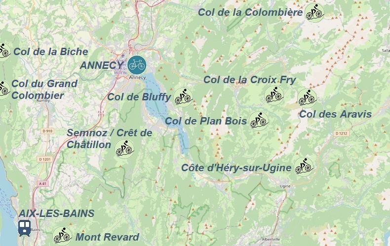
Hills accessible from Annecy:
1. 120km - Col de Bluffy: 631m
- Col de Plan Bois: 1299m
- Col de la Croix Fry: 1477m
- Col des Aravis: 1486m
- Côte d'Héry-sur-Ugine: 937m
2. 53km - Semnoz / Crêt de Châtillon: 1665m
3. 98km - Mont Revard: 1538m
- Semnoz / Crêt de Châtillon: 1665m
4. 102km - Col de la Colombière: 1618m
- Col de la Croix Fry: 1477m
5. 110km - Col du Grand Colombièr: 1501m
- Col de la Biche: 1325m


EMBRUN
To get to Embrun the fastest, we can fly to Aéroport Marseille-Provence; information on how to find a convenient flight, combined with rail and bus transportation, can be found in the transport section;
One of the many ways to get to Embrun conveniently is:
After arriving at Aéroport Marseille-Provence we go to the bus stop, from where buses of the L40 line depart every 30 minutes towards Gare Routière de Aix-en-Provence (the journey takes about 30 minutes); the ticket price is 10€, the timetable can be found on the airport's website in PDF format and the ticket can be purchased online;
We get off at the last stop Aix-en-Provence - Gare Routière and after an 8-minute (500m) walk to the train station, we change to a direct train from Aix-en-Provence to Embrun; (it's important not to confuse the Gare de Aix-en-Provence station with the Aix-en-Provence TGV station, which is earlier); tickets can be purchased on the sncf-connect.com website;
We get off at the Gare de Embrun station;
Upon arrival in Embrun, we head to the previously booked accommodation; good places to search for accommodation are trusted services: airbnb.com and booking.com;
If we want to take advantage of the gastronomic offer, we can find the locations of gastronomic points on the mapy.cz website;
If you're not hungry, you can head straight to the most important point of the program...
Alpes 2 Routes road bike rental is located at: 6 Prom. de la Digue, 05200 Embrun; it's worth reserving a bike well in advance to be sure of renting a bike upon arrival; current bike rental prices can be found on the above-mentioned rental website;
All proposed cycling routes (gpx traces) from the town of Embrun start at the Gare de Embrun train station or after arriving by train at the stations: Gare de Mont-Dauphin - Guillestre, Gare de Chorges, and Gare de Briançon;
If we arrived in Embrun by car, we must find a safe parking space; paid and free parking spaces are shown on the
mapy.cz website;
For more information about the town and its surroundings, visit the ville-embrun.fr website;
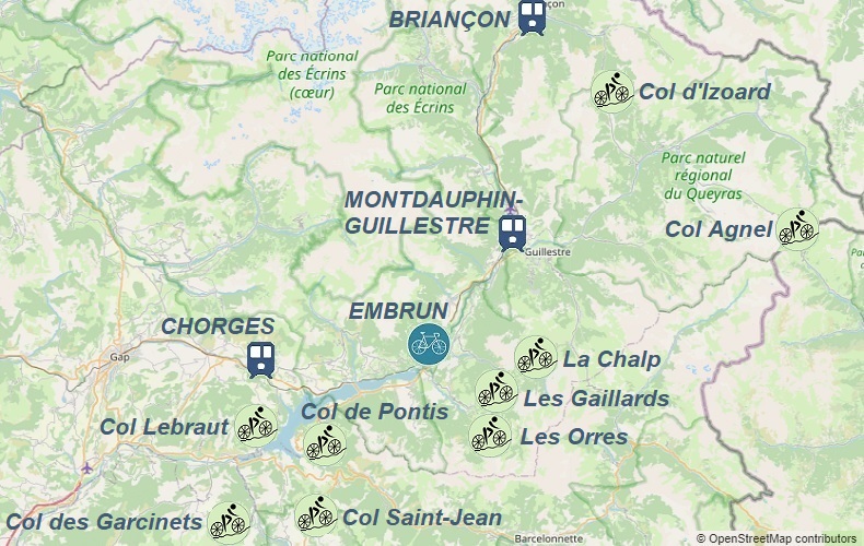
Hills accessible from Embrun:
1. 110km - Col Agnel: 2744m
2. 72km - Les Orres: 1663m
- Les Gaillards: 1372m
- La Chalp: 1670m
3. 71km - Col d'Izoard: 2360m
- Semnoz / Crêt de Châtillon: 1665m
4. 93km - Col Lebraut: 1110m
- Col des Garcinets: 1185m
- Col Saint-Jean: 1332m
- Col de Pontis: 1301m


BARCELONNETTE
The fastest way to get to Barcelonnette is by flying to Aéroport Marseille-Provence lub Aéroport Nice Côte d'Azur; information on how to find a convenient flight combined with rail and bus transport can be found in the transport section;
One of the many ways to get to Barcelonnette conveniently is as follows:
After arriving at Aéroport Marseille-Provence we head to the bus stop, where buses of line L40 depart every 30 minutes towards Gare Routière de Aix-en-Provence (the journey takes about 30 minutes); the ticket price is 10€, the timetable can be found on the airport website in PDF format, and the ticket can be purchased online;
We get off at the last stop Aix-en-Provence - Gare Routière and after an 8-minute walk (500m) to the train station, we change to a direct train from Aix-en-Provence to Gap (it is important not to confuse the Gare de Aix-en-Provence station with the Aix-en-Provence TGV station, which is earlier). Tickets can be purchased on the sncf-connect.com website;
We get off at Gare de Gap station and change to bus line 30, which takes 1 hour and 45 minutes to reach Barcelonnette, where we get off at the Barcelonnette - Place Aimé Gassier stop;
Upon arrival in Barcelonnette, we head to the previously booked accommodation. Good places to look for accommodation are trusted websites such as airbnb.com and booking.com;
If we want to take advantage of the gastronomic offer, we can find the locations of gastronomic points on the mapy.cz website;
If we are not hungry, we do not waste time and head to the most important point of the program...
The road bike rental Granphi Sports is located at: 51 avenue des 3 frères Arnaud, 04400 Barcelonnette; it is worth reserving a bike well in advance to be sure of renting a bike upon arrival. Current bike rental prices can be found on the rental company's website.
All proposed cycling routes (gpx tracks) from the town of Barcelonnette start at Place Aimé Gassier.
If we arrive in Barcelonnette by car, we must find a safe parking space; paid and free parking lots are shown on the mapy.cz website;
For more information about the town and its surroundings, visit ville-barcelonnette.fr website;
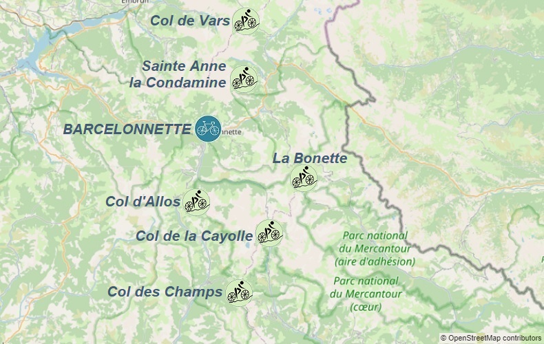
Hills accessible from Barcelonnette:
1. 64km - La Bonette: 2802m
2. 121km - Col de la Cayolle: 2326m
- Col des Champs: 2089m
- Col d'Allos: 2247m
3. 75km - Col de Vars: 2109m
- Sainte Anne la Condamine: 1833m


BÉDOIN
To get to Bédoin fastest, the best option is to fly to Aéroport Marseille-Provence; information on how to find a convenient flight connected with rail and bus transport can be found in the transport section;
One of the many options for getting to Bédoin conveniently is as follows:
After arriving at Aéroport Marseille-Provence, go to the bus stop where buses of line 13 depart every 15 minutes towards Gare de Vitrolles Aéroport Marseille (the journey takes about 5 minutes); the ticket price is 1.20€ and the timetable can be found on the airport's website in jpg format;
From the Gare de Vitrolles Aéroport Marseille railway station, take a regional train to Avignon Centre, where you change to a train to Carpentras; the entire journey, including transfer time, takes about 1 hour and 45 minutes.
In Carpentras, take the L bus line, which runs to Bédoin 4 times a day - the timetable and ticket purchase option are available on the transcove.com website; the journey takes 34 minutes;
After arriving in Bédoin by bus, go to the previously booked accommodation; good places to search for accommodation are trusted websites such as airbnb.com and booking.com;
If you want to take advantage of the culinary offer, you can find the locations of gastronomic points on the mapy.cz website;
If you are not hungry, do not waste time and go to the most important point of the program...
Road bike rentals:
- France Bike Rentals is located at: 57 Route Du Mont Ventoux 84410 Bédoin;
- Camp de Base Ventoux is located at: 192 Route du Mont Ventoux, 84410 Bédoin;
- Bédoin Location is located at: 20 Rte de Malaucène, 84410 Bédoin;
It is worth reserving a bike well in advance to be sure of renting a bike upon arrival; current bike rental prices can be found on the above rental websites;
All proposed cycling routes (GPX tracks) from the town of Bédoin start at the P6 car park at Place du Portail.
If you arrive in Bédoin by car, you must find a safe parking space;
Paid and free parking spaces are shown on the mapy.cz website;
More information about the town and its surroundings can be found on the bedoin-mont-ventoux.fr website;
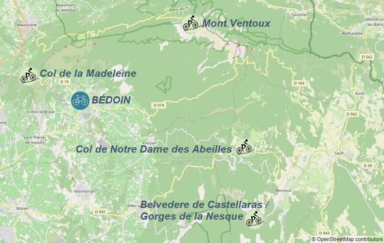
Hills accessible from Bedoin:
1. 55km - Mont Ventoux: 1893m
- Col de la Madeleine: 448m
2. 64km - Col de Notre Dame des Abeilles: 996m
- Belvedere de Castellaras / Gorges de la Nesque: 724m

