

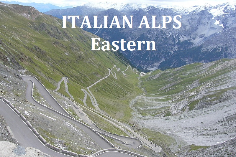
ITALIAN ALPS - Eastern
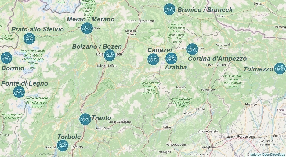
Bormio: Passo dello Stelvio, Passo Eira...
Ponte di Legno: Passo di Gavia, Passo Mortirolo...
Prato allo Stelvio: Passo dello Stelvio, Plawenn / Piavenna...
Bolzano / Bozen: Passo Mendola / Mendelpass, Passo Pampeago...
Canazei: Passo Pordoi, Passo Sella...
Arabba: Passo Sella, Passo Valparola...
Cortina d'Ampezzo: Passo Giau, Tre Cime di Lavaredo...
Tolmezzo: Monte Zoncolan, Monte Crostis...
Trento: Monte Bondone, Passo Manghen...
Torbole: Monte Baldo, Passo Bordala...
Bruneck / Brunico: Passo Furcia, Passo delle Erbe...
Merano / Meran: Maso Corto, Passo del Rombo...
BORMIO
To get to Bormio the fastest way, we can fly to Milan Bergamo Airport (BGY), Milan Malpensa Airport (MXP), or Milan Linate Airport (LIN);
Information on how to find a favorable flight connected with railway and bus transportation can be found in the transport section;
One of many possibilities for a favorable trip to Bormio is as follows:
After arriving at Milan Bergamo Airport (BGY), we go to the bus stop, where we can take a bus to the center of Milan within an hour, where we transfer to a regional train to Tirano (the journey takes 2h45min); in Tirano, we switch to a bus to Bormio - the timetable can be found on the carrier's website;
Upon arriving in Bormio, we can walk or take a taxi to the previously booked accommodation; good places to look for accommodation are trusted services such as airbnb.com and booking.com;
Depending on the arrival time, before heading to the bike rental, it's worth taking advantage of the wide range of dining options; the locations of gastronomic points can be found on the mapy.cz website;
If we're not hungry, we don't waste time and head straight to the main point of the program...
The Celso Bike road bike rental is located at Via Battaglion Morbegno 1, 23032 Bormio; it's worth reserving a bike well in advance to ensure bike rental upon arrival; current bike rental prices can be found on the rental website.
All proposed road cycling routes (GPX tracks) from the town of Bormio start at the parking lot near the lower station of the Cabinovia Bormio - Bormio 2000 cable car.
If we arrived in Bormio by car, we need to find a safe parking spot. Paid and free parking lots are shown on the mapy.cz website;
For more information about the town and its surroundings, visit the official Bormio website.
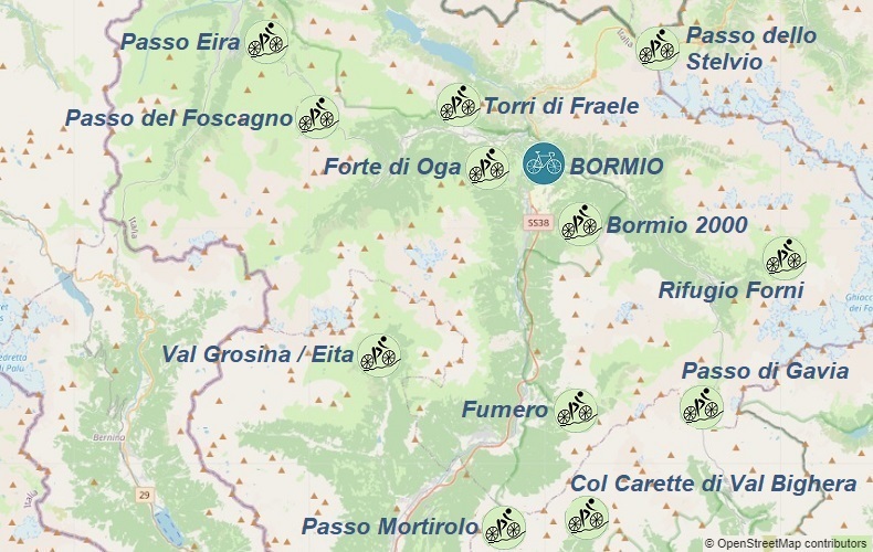
Hills accessible from Bormio:
1. 44km - Passo dello Stelvio: 2758m.a.s.l.
2. 63km - Passo di Gavia: 2618m.a.s.l.
- Rifugio Forni: 2176m.a.s.l.
3. 77km - Passo del Foscagno: 2291m.a.s.l.
- Passo Eira: 2208m.a.s.l.
4. 42km - Forte di Oga: 1720m.a.s.l.
- Torri di Fraele: 1941m.a.s.l.
5. 78km - Val Grosina / Eita: 1698m.a.s.l.
6. 91km - Passo Mortirolo: 1852m.a.s.l.
- Col Carette di Val Bighera: 2130m.a.s.l.
7. 107km - Passo Mortirolo: 1852m.a.s.l.
- Passo di Gavia: 2618m.a.s.l.
8. 61km - Bormio 2000: 1944m.a.s.l.
- Fumero: 1484m.a.s.l.


PONTE DI LEGNO
To get to Ponte di Legno the fastest way, we can fly to Milan Bergamo Airport (BGY), Milan Malpensa Airport (MXP), or Milan Linate Airport (LIN);
Information on how to find a favorable flight connected with railway and bus transportation can be found in the transport section;
Upon arrival, we head to the bus stop, from where the BS1 line buses depart three times a day towards Ponte di Legno with a transfer in Edolo. The ticket price is 8€, and the journey takes 3 hours. The timetable can be found on the bergamotrasporti.it website;
Upon arriving in Ponte di Legno, we can walk or take a taxi to the previously booked accommodation; good places to look for accommodation are trusted services such as airbnb.com and booking.com;
Depending on the arrival time, before heading to the bike rental, it's worth taking advantage of the wide range of dining options; the locations of gastronomic points can be found on the mapy.cz;
If we're not hungry, we don't waste time and head straight to the main point of the program...
The road bike rental Pontedilegno Ski School is located at: Corso Milano, 36 - 25056
Ponte di Legno; It is worth booking a bike well in advance to ensure its availability upon arrival. The current rental prices can be found on the rental website;
All road cycling route proposals (GPX tracks) from Ponte di Legno start at the parking lot on Via Cida;
If we arrived in Bormio by car, we need to find a safe parking spot. Paid and free parking lots are shown on the
mapy.cz website;
For more information about Ponte di Legno and the surrounding area, visit the website: pontedilegnotonale.com;
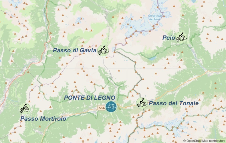
Hills accessible from Ponte di Legno:
1. 42km - Passo di Gavia: 2618m.a.s.l.
2. 89km - Passo Mortirolo: 1852m.a.s.l.
3. 97km - Passo del Tonale: 1884m.a.s.l.
- Peio: 1572m.a.s.l.


PRATO ALLO STELVIO / PRAD AM STILFSER JOCH
To reach Prato allo Stelvio / Prad am Stilfser Joch the quickest way is to fly to Verona Airport (VRN) or Milan Bergamo Airport (BGY); information on finding a favorable flight combined with rail and bus transport can be found in the transport section;
After arrival, we head to the bus stop, from where Verona Airlink buses depart every 20 minutes towards Verona Stazione Porta Nuova railway station; the ticket price is 6€ and the schedule can be found on atv.verona.it.
We change to a train, which with 1 transfer in Bolzano will take us to Meran/Merano; the schedule with the option to purchase a ticket can be found on trenitalia.com;
In Meran/Merano we change to a train to Spondinig (schedule available on the carrier's website: sad.it) and then take bus line 271, which will take us to Prato in 5 minutes.
Upon arriving in Prato allo Stelvio / Prad am Stilfser Joch, we can walk or take a taxi to the previously booked accommodation; good places to look for accommodation are trusted services such as airbnb.com and booking.com;
If we want to take advantage of the gastronomic offer, we can find the locations of gastronomic points on the map.cz website;
If we're not hungry, we don't waste time and head straight to the main point of the program...
Baldi Sport road bike rental is located at: Reutweg / Via Nuova 19, 39026 Prad am Stilfserjoch / Prato allo Stelvio;
It's worth booking a bike well in advance to ensure bike rental upon arrival;
All proposed cycling routes (GPX traces) from the town of Prato allo Stelvio start at the parking lot at Dornweg - Via delle Spine;
If we arrive in Prato allo Stelvio by car, we need to find a safe parking spot;
Paid and free parking lots are shown on the
mapy.cz website;
For more information about the town and its surroundings, please visit gemeinde.prad.bz.it website
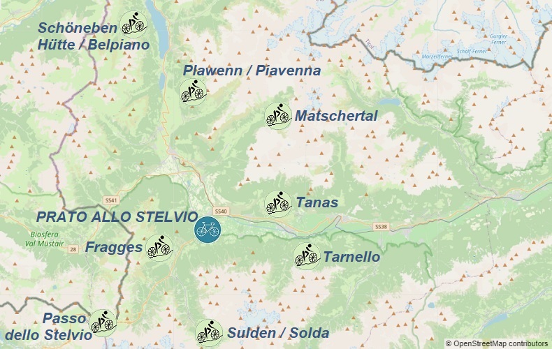
Hills accessible from Prato allo Stelvio / Prad am Stilfser Joch:
1. 63km - Passo dello Stelvio: 2758m.a.s.l.
2. 50km - Tarnello: 1410m.a.s.l.
- Tanas: 1590m.a.s.l.
3. 47km - Sulden / Solda: 1934m.a.s.l.
- Fragges: 1683m.a.s.l.
4. 104km - Matschertal: 1822m.a.s.l.
- Plawenn / Piavenna: 1683m.a.s.l.
- Schöneben Hütte / Belpiano: 2118m.a.s.l.


BOLZANO / BOZEN
To get to Bolzano, the quickest way is to fly to Verona Airport (VRN); other arrival options and information on how to find a convenient flight connected with railway and bus transport can be found in the "Transport" section;
Upon arrival, we head to the bus stop, from where Verona Airlink buses depart every 20 minutes towards Verona Stazione Porta Nuova railway station; the ticket price is 6€ and the timetable can be found on atv.verona.it website;
We change to a train that takes us directly to Bolzano; the timetable with the possibility to buy a ticket can be found on trenitalia.com website;
Information about public transport in Bolzano can be found on altoadigemobilita.info website;
Straight from the railway station, we arrive at the previously reserved accommodation; good places to search for accommodation are verified services such as airbnb.com and booking.com;
If we want to take advantage of the gastronomic offer, we can find the locations of gastronomic points on the mapy.cz website;
if we're not hungry, we don't waste time and head straight to the most important point on the agenda...
Sport Service road bike rental is located at Rittnerstr. Via Renon 45, 39100 Bozen; (near the Rittner cable car)
It's worth booking a bike well in advance to ensure bike rental upon arrival;
If we arrive in Bolzano by car, we need to find a safe parking spot; paid and free parking lots are shown on the mapy.cz website;
Below are the proposed trips from Bolzano/Bozen - all GPX traces start at Bolzano/Bozen railway station or after arriving by train at Sterzing/Vipiteno or Lana stations;
For more information about Bolzano/Bozen and its surroundings, please visit suedtirol.info.
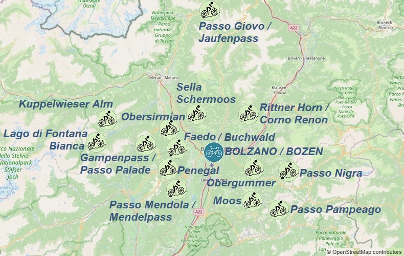
Hills accessible from Bolzano:
1. 77km - Passo Nigra: 1690m.a.s.l.
- Obergummer / San Valentino di Soprano: 1345m.a.s.l.
2. 90km - Passo Giovo / Jaufenpass: 2094m.a.s.l.
3. 53km - Sella Schermoos: 1450m.a.s.l.
4. 42km - Rittner Horn / Corno Renon: 1535m.a.s.l.
5. 78km - Passo Mendola / Mendelpass: 1363m.a.s.l.
- Penegal: 1720m.a.s.l.
- Buchwald / Faedo: 951m.a.s.l.
6. 125km - Lago di Fontana Bianca: 1880m.a.s.l.
- Kuppelwieser Alm: 1969m.a.s.l.
7. 99km - Obersirmian / Sirmiano di Sopra: 1043m.a.s.l.
- Gampenpass / Passo Palade: 1518m.a.s.l.
- Passo Mendola / Mendelpass: 1363m.a.s.l.
8. 103km - Obergummer / San Valentino di Soprano: 1345m.a.s.l.
- Passo Pampeago: 1996m.a.s.l.
- Moos: 1423m.a.s.l.


CANAZEI
To get to Canazei the fastest, the best option is to fly to Verona Airport (VRN); other arrival options and information on how to find a convenient flight combined with train and bus transportation can be found in the transport section;
After arrival, we head to the bus stop where Verona Airlink buses depart every 20 minutes towards Verona Stazione Porta Nuova railway station. The ticket price is €6 and the timetable can be found on atv.verona.it;
We transfer to a train that will take us directly to the Ora/Auer train station. The timetable with the possibility of buying a ticket can be found on trenitalia.com;
At Ora/Auer, we transfer to bus line B140, which with a transfer in Cavaleze and then on bus line B101, will take us to Canazei in 2 hours and 20 minutes. The ticket costs around €6-10 and the buses run every hour. More information can be found on trentinotrasporti.it
From the bus stop, we go straight to our pre-booked accommodation. Good places to search for accommodation are trusted services like airbnb.com and booking.com.
If we want to take advantage of the gastronomic offer, the locations of restaurants can be found on mapy.cz;
If we are not hungry, we don't waste time and head to the most important point of our program...
Peak Sport Adventure road bike rental is located at: Strèda de Pareda 83 | 38032 Canazei; it's worth reserving a bike well in advance to be sure of renting one upon arrival.
If we arrived in Canazei by car, we need to find a safe parking spot. Paid and free parking lots are shown on mapy.cz
Below are some suggested trips from Canazei - all gpx tracks start at the parking lot at Strèda del Piz, located opposite the bike rental and the starting point of the Funivie Belvedere cable car.
More information about the town and its surroundings can be found on comune.canazei.tn.it;
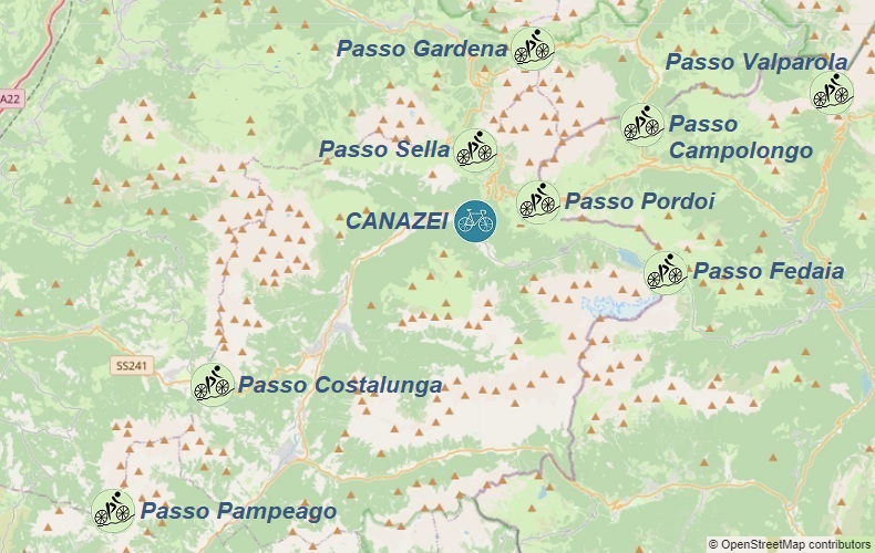
Hills accessible from Canazei:
1. 66km - Passo Pordoi: 2239m.a.s.l.
- Passo Fedaia: 2057m.a.s.l.
2. 64km - Passo Sella: 2218m.a.s.l.
- Passo Gardena: 2121m.a.s.l.
- Passo Campolongo: 1875m.a.s.l.
- Passo Pordoi: 2239m.a.s.l.
3. 99km - Passo Fedaia: 2057m.a.s.l.
- Passo Valparola: 2192m.a.s.l.
- Passo Gardena: 2121m.a.s.l.
- Passo Sella: 2218m.a.s.l.
4. 96km - Passo Pampeago: 1996m.a.s.l.
- Passo Costalunga: 1752m.a.s.l.


ARABBA
Arabba is an ideal place for a 3-day stay in the Dolomites. Starting from Arabba, we can complete 3 loop routes without repeating any sections. All loops are ridden clockwise, so we will ascend Passo Campolongo and Passo Pordoi twice, but from different sides;
The quickest way to get to Arabba is by car;
Upon arrival, go to your pre-booked accommodation. Good places to search for accommodation are the reliable sites: airbnb.com and booking.com;
Paid and free parking options are shown on the mapy.cz website;
If you want to take advantage of the dining options, the locations of eateries can be found on the mapy.cz website;
Below are some trip suggestions starting from Arabba - all GPX tracks start at the roundabout in the town center;
For more information about the town and its surroundings, visit arabba.it;
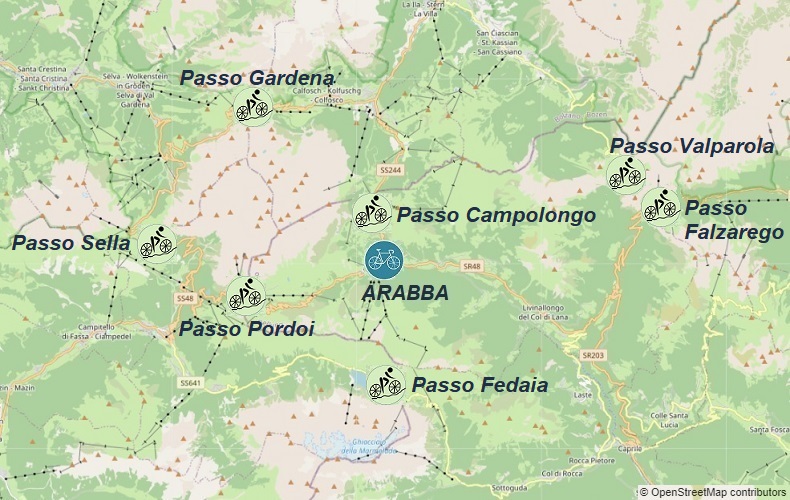
Hills accessible from Arabba:
1. 52km - Passo Pordoi: 2239m
- Passo Sella: 2244m
- Passo Gardena: 2121m
- Passo Campolongo: 1875m
2. 51km - Passo Campolongo: 1875m
- Passo Valparola: 2092m
3. 65km - Passo Fedaia: 2057m
- Passo Pordoi: 2239m


CORTINA D'AMPEZZO
To reach Cortina d'Ampezzo the quickest way is to fly to Aeroporto di Venezia Marco Polo
(VCE); information on finding a convenient flight with railway and bus connections can be found in the transport section;
After arrival, we head to the bus stop where, depending on the arrival time, we have a choice of 3 lines: Cortina Express, Flixbus lub ATVO;
Straight from the bus stop, we reach the previously booked accommodation; good places to look for accommodation are trusted websites such as airbnb.com and booking.com.
If we want to take advantage of the gastronomic offer, we can find the locations of gastronomic points on mapy.cz;
if we are not hungry, we do not waste time and head straight to the most important point of the program...
The road bike rental Snow Service is located at: Via G. Marconi, 12/c 32043 Cortina d'Ampezzo; it is worth booking a bike well in advance to be sure of renting a bike upon arrival.
If we have arrived in Cortina d'Ampezzo by car, we must find a safe parking lot; paid and free parking lots are shown on mapy.cz
Below are some excursion proposals from Cortina d'Ampezzo - all gpx traces start at the bus station parking lot.
For more information about the town and its surroundings, visit comunecortinadampezzo.bl.it;

Hills accessible from Cortina d'Ampezzo:
1. 69km - Passo Giau: 2236m.a.s.l.
- Passo Falzarego: 2105m.a.s.l.
2. 54km - Passo Tre Croci: 1809m.a.s.l.
- Tre Cime di Lavaredo: 2357m.a.s.l.
3. 96km - Passo Cibiana: 1530m.a.s.l.
- Passo Staulanza: 1773m.a.s.l.
- Passo Giau: 2236m.a.s.l.
4. 84km - Passo Falzarego: 2105m.a.s.l.
- Passo Campolongo: 1875m.a.s.l.
- Passo Valparola: 2192m.a.s.l.


TOLMEZZO
To reach Tolmezzo quickly, the best way is to fly to either Aeroporto di Venezia Marco Polo (VCE) or Aeroporto di Treviso-Sant'Angelo (TSF); information on how to find a convenient flight connected with train and bus transport can be found in the transport section;
One of the many options to get to Tolmezzo is:
After arriving at Aeroporto di Treviso-Sant'Angelo (TSF), head to the bus stop where you can take bus line 101 (runs approximately every 20 minutes - ticket cost is 1-2€) to Treviso train station, where trains to Udine run more than once an hour and cost about 11€. The train schedule with the possibility to purchase tickets can be found on trenitalia.com; In Udine, transfer to bus line 100 and arrive in Tolmezzo in 50 minutes - ticket cost is about 6€; more information can be found on mycicero.it
Straight from the bus stop, you can reach your previously booked accommodation. Good places to search for accommodation are reliable services like airbnb.com and booking.com.
If you want to take advantage of the gastronomic offer, you can find the locations of gastronomic points on mapy.cz;
If you are not hungry, don't waste time and head straight to the main point of the program...
Road bike rental Carnia Rent Bike is located at: Via Grialba 35, 33028 Tolmezzo; It is worth booking a bike well in advance to ensure availability upon arrival.
If you arrive in Tolmezzo by car, you will need to find a safe parking spot. Paid and free parking spots are shown on mapy.cz
Below are some suggested trips from Tolmezzo - all gpx tracks start at the parking lot near the bus station.
For more information about the town and its surroundings, visit to Tolmezzo;
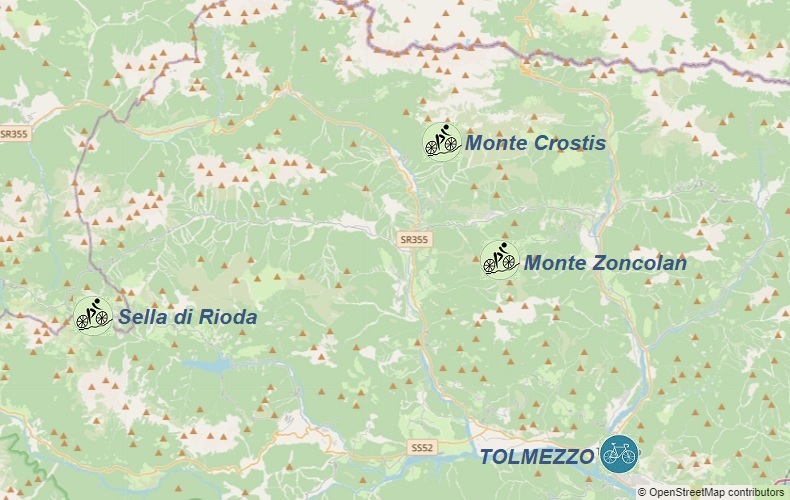
Hills accessible from Tolmezzo:
1. 58km - Monte Zoncolan: 1737m.a.s.l.
2. 78km - Monte Crostis: 1982m.a.s.l.
3. 96km - Sella di Rioda: 1800m.a.s.l.


TRENTO
To reach Trento the fastest, we can fly to Verona Airport (VRN); other arrival options and information on how to find a convenient flight combined with train and bus transportation can be found in the transport section;
Upon arrival, we head to the bus stop where Verona Airlink buses depart every 20 minutes towards Verona Stazione Porta Nuova train station. The ticket price is 6€, and the timetable can be found on atv.verona.it;
We transfer to a train that will take us directly to the Trento train station. The train schedule and ticket purchase information can be found on trenitalia.com;
Information on public transportation can be found on trentinotrasporti.it
Using the above information, we can easily reach our pre-booked accommodation straight from the train station. Airbnb.com and booking.com are good places to search for accommodation.
If we want to enjoy the local cuisine, we can find the locations of gastronomic points on mapy.cz;
If we are not hungry, we can head straight to the most important point of our itinerary...
Presta Bici road bike rental shop is located at: Corso Michelangelo Buonarroti 70, 38122 Trento; It's worth reserving a bike well in advance to ensure availability upon arrival.
If we arrive in Trento by car, we need to find a safe parking spot. Paid and free parking locations are shown on mapy.cz
Below are some suggested tours from Trento - all GPX tracks start at the parking lot near the lower station of the Funivia Trento - Sardagna cable car or after arriving by train at Mezzocorona, Roveretto or Borgo Valsugana stations.
For more information on the city and surrounding areas, visit visittrentino.info;
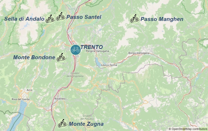
Hills accessible from Trento:
1. 88km - Passo Manghen: 2042m.a.s.l.
2. 53km - Monte Bondone: 1650m.a.s.l.
3. 103km - Passo Santel: 1040m.a.s.l.
- Sella di Andalo: 1043m.a.s.l.
- Monte Bondone: 1650m.a.s.l.
4. 65km - Monte Zugna: 2042m.a.s.l.


TORBOLE
To get to Torbole the fastest way, we can fly to Verona Airport (VRN); other arrival options and information on how to find a convenient flight combined with train and bus transportation can be found in the transport section;
After arrival, we go to the bus stop, where Verona Airlink buses depart every 20 minutes towards Verona Stazione Porta Nuova railway station; the ticket price is €6 and the schedule can be found on atv.verona.it;
We transfer to a train that will take us directly to Mori train station; the timetable with the option to buy a ticket can be found on trenitalia.com;
We transfer to bus line BS332 or B301 and arrive in Torbole in 23 minutes; information on public transport in the Trentino region can be found on trentinotrasporti.it
Straight from the bus stop, we arrive at the previously booked accommodation; good places to look for accommodation are trusted services such as airbnb.com and booking.com;
If we want to take advantage of the gastronomic offer, we can find the locations of gastronomic points on mapy.cz;
if we are not hungry, we do not waste time and head to the most important point of the program...
Mandelli Bike road bike rental is located at: Via Giacomo Matteotti 83, 38069 Nago-Torbole; it's worth booking a bike well in advance to ensure availability upon arrival;
If we arrive in Torbole by car, we must find a safe parking spot; paid and free parking spaces are shown on mapy.cz
Below are some excursion proposals from the town of Torbole - all GPX traces start at the parking lot: Parcheggio Goethe on Via Strada Granda;
more information on transport and parking in the town and surrounding areas can be found on comune.nago-torbole.tn.it;
More information about the town and its surroundings can be found on visittrentino.info;
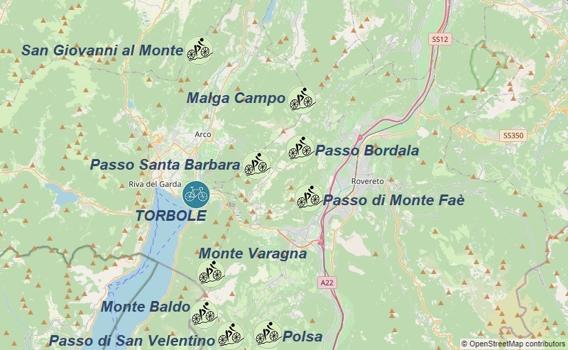
Hills accessible from Torbole:
1. 100km - Monte Baldo: 1617m.a.s.l.
- Passo di San Valentino: 1314m.a.s.l.
- Polsa: 1301m.a.s.l.
2. 66km - Passo Bordala: 1250m.a.s.l.
- Passo di Monte Faè: 932m.a.s.l.
3. 67km - Passo Santa Barbara: 1170m.a.s.l.
- Monte Varagna: 1569m.a.s.l.
4. 83km - San Giovanni al Monte: 1105m.a.s.l.
- Malga Campo: 1372m.a.s.l.


BRUNECK / BRUNICO
To get to Bruneck/Brunico the fastest way, we can fly to Verona Airport (VRN); other arrival options and information on how to find a convenient flight combined with train and bus transportation can be found in the transport section;
After arrival, we head to the bus stop, where Verona Airlink buses depart every 20 minutes towards Verona Stazione Porta Nuova train station; the ticket price is 6€, and the schedule can be found on atv.verona.it;
We transfer to a train with one transfer in Bolzano/Bozen to reach the Bruneck/Brunico train station; the schedule with the option to buy a ticket can be found on trenitalia.com;
Information on public transport in the Trentino region can be found on trentinotrasporti.it
From the train station, we reach our previously booked accommodation; good places to search for accommodation are trusted services such as airbnb.com and booking.com;
If we want to take advantage of the culinary offer, we can find the locations of gastronomic points on mapy.cz;
if we're not hungry, we don't waste time and head straight to the most important point of the program...
Sportservice | Bici Alto Adige road bike rental is located at: Via Michael Pacher 23, 39031 Brunico / Bruneck; it's worth reserving a bike well in advance to be sure of renting a bike upon arrival.
If we have arrived in Bruneck/Brunico by car, we must find a safe parking spot; paid and free parking spots are shown on mapy.cz
Below are proposed excursions from the town of Bruneck/Brunico - all gpx tracks start at the Bruneck/Brunico train station or after arriving by train at the Vintl/Vandoies and Mühlbach/Rio di Pusteria stations;
For more information on the town and surrounding areas, visit suedtirol.info;
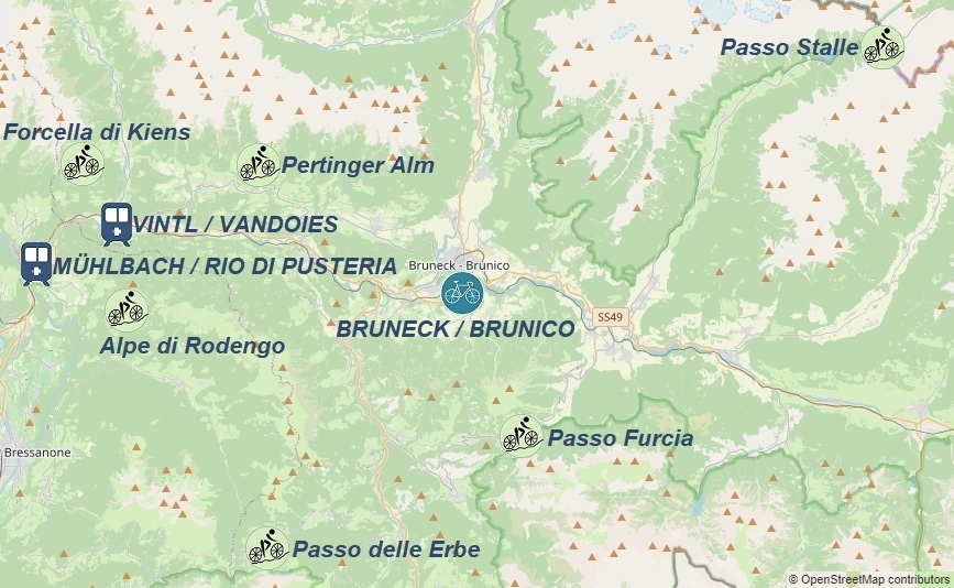
Hills accessible from Brunico / Bruneck :
1. 45km - Passo Furcia: 1789m.a.s.l.
2. 65km - Alpe di Rodengo: 1727m.a.s.l.
- Passo delle Erbe: 1987m.a.s.l.
3. 61km - Forcella di Kiens: 1743m.a.s.l.
- Pertinger Alm: 1587m.a.s.l.
4. 76km - Passo Stalle: 2052m.a.s.l.


MERANO / MERAN
To reach Merano/Meran the fastest, the easiest way is by flying to Verona Airport (VRN); other arrival options and information on how to find a convenient flight combined with train and bus transportation can be found in the transport section;
Upon arrival, we go to the bus stop, from where Verona Airlink buses depart every 20 minutes towards Verona Stazione Porta Nuova railway station. The ticket price is 6€, and the schedule can be found on atv.verona.it;
We change to the train, with one transfer in Bolzano/Bozen, to reach Merano/Meran railway station. The timetable with the possibility of buying a ticket can be found on the trenitalia.com website;
Information about public transport in the Trentino region can be found trentinotrasporti.it
From the railway station, we reach the previously booked accommodation. Good places to search for accommodation are reliable services such as airbnb.com and booking.com.
If we want to take advantage of the gastronomic offer, we can find the locations of gastronomic points on mapy.cz;
If we are not hungry, we do not waste time and go straight to the most important point of the program...
Sportservice | Bici Alto Adige road bike rental is located at: Pala Mainardo Entrata da Viale Europa, di fronte alla stazione dei pullman, 39012 Merano ; The exact location of the rental can be found on the above-mentioned website. It is worth reserving a bike well in advance to ensure bike rental upon arrival.
If we arrive in Merano/Meran by car, we must find a safe parking spot. Paid and free parking lots are shown on mapy.cz
Below are proposals for trips from the town of Merano/Meran - all GPX tracks start at the parking lot at Merano/Meran railway station.
For more information on the town and surrounding areas, visit suedtirol.info;
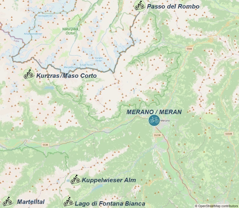
Hills accessible from Merano / Meran:
1. 79km - Kurzras / Maso Corto: 2009m
2. 102km - Passo del Rombo: 2474m
3. 112km - Lago di Fontana Bianca: 1880m
- Kuppelwieser Alm: 1969m
4. 75km - Martelltal: 2079m


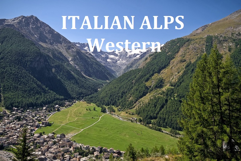
ITALIAN ALPS - Western
Cycling routes by starting location:
To all of the presented starting locations, you can drive with your own bike by car.
If you decide to use public transportation, you will find a handful of information on the following pages:
The nearest airports to all routes in the Italian Alps in the western part are Aeroporto di Torino (TRN), Milan Bergamo Airport (BGY), Aeroporto di Milano Malpensa (MXP) or Aeroporto di Milano Linate (LIN);
Which airport to choose depends on where and on what day of the week we want to arrive;
Details and proposals for connections from airports to "starting" towns can be found on the following pages describing individual towns, which we can choose from the map below by clicking on the bike icon.
Proposals for flight connections to Milan and Turin can be found in transport section.
CHÂTILLON
To get to Châtillon fastest, we can fly to Aeroporto di Torino; information on arrivals at other airports and how to find a convenient flight connected with rail and bus transportation can be found in the transport section;
One of many options for getting to Châtillon conveniently is:
We transfer to a direct train from Torino Porta Nuova to the Chatillon-Saint Vincent station; the train takes 1h34min, and the ticket costs about €9.
Information on public transportation in the Aosta Valley can be found on the arriva.it website;
Information on public transportation in the Aosta Valley can be found on the aosta.arriva.it website;
After arriving in Châtillon using public transportation, we reach the previously booked accommodation. Good places to search for accommodation are trusted services such as airbnb.com and booking.com.
If we want to take advantage of the gastronomic offer, we can find the locations of gastronomic points on the mapy.cz website;
If we are not hungry, we do not waste time and head to the most important point of the program...
Italy Cycling Tours road bike rental is located at: Via Tollen, 46 Châtillon, Aosta;
It is worth reserving a bike well in advance to ensure that we can rent a bike upon arrival. Current bike rental prices can be found on the rental company's website;
All proposed cycling routes (GPX tracks) from the town of Châtillon start at the parking lot on Via Robert Pellissier.
If we arrive in Châtillon by car, we need to find a safe parking spot.
Paid and free parking options are shown on
mapy.cz; Parking is also available near the bike rental.
More information about the town and its surroundings can be found on comune.chatillon.ao.it
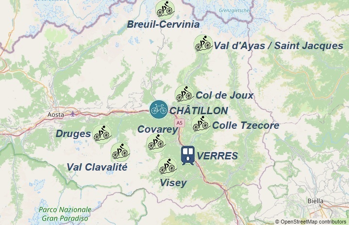
Hills accessible from Châtillon:
1. 59km - Breuil-Cervinia: 2113m
2. 86km - Colle Tzecore: 1607m
- Val d'Ayas / Saint Jacques: 1713m
- Col de Joux: 1646m
3. 57km - Visey: 1421m
- Covarey: 1290m
4. 67km - Druges: 1592m
- Val Clavalité: 1526m


AOSTA
To get to Aosta the quickest way is by flying to Aeroporto di Torino airport; information on arrivals to other airports and how to find affordable flights combined with train and bus transport can be found in the transport section;
One of the many affordable ways to get to Aosta is to take bus line 268 every 15-30 minutes from the bus stop at Aeroporto di Torino towards Torino Porta Nuova (approximately 50 minutes journey); the ticket costs around €8 and the timetable can be found on the arriva.it website;
Then transfer to a direct train from Torino Porta Nuova to Aosta station; the train journey takes 1 hour and 55 minutes and the ticket costs around €10.
Information on public transport in the Aosta Valley can be found on the aosta.arriva.it website;
Upon arrival in Aosta, using public transport, we can reach the pre-booked accommodation. Good places to look for accommodation are trusted services such as airbnb.com and booking.com;
If we want to enjoy the local cuisine, the locations of the gastronomic points can be found on the mapy.cz website;
If we are not hungry, we can head straight to the main point of the program...
The Place Aosta road bike rental is located at: Via Ruelle des Fermes 9, 11100 Aosta;
It is worth reserving a bike well in advance to ensure availability upon arrival; The current bike rental prices can be found on the rental company's website;
All proposed cycling routes (gpx traces) from the town of Aosta start at Aosta railway station or after arriving by regional train at Chatillon-Saint Vincent station;
If we arrive in Aosta by car, we must find a safe parking spot. Paid and free parking options can be found on the
mapy.cz website;
More information about the town and its surroundings can be found on the Valle d'Aosta website.
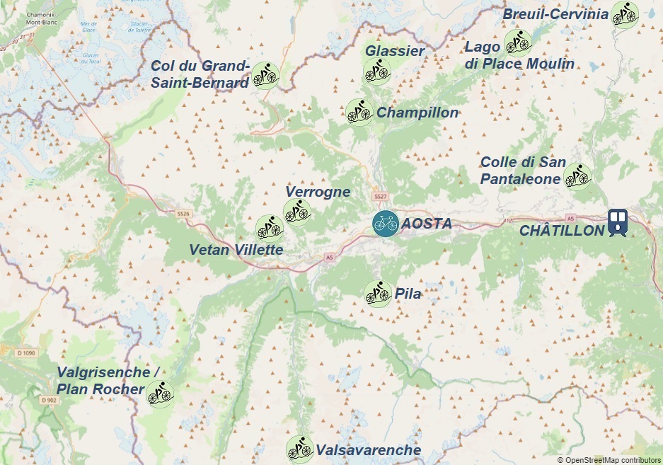
Hills accessible from Aosta:
1. 80km - Valsavarenche: 1960m
2. 70km - Col du Grand-Saint-Bernard: 2473m
3. 82km - Valgrisenche / Plan Rocher: 1975m
4. 65km - Breuil-Cervinia: 2113m
- Colle di San Pantaleone: 1655m
5. 40km - Pila: 1805m
6. 70km - Champillon: 2074m
- Glassier: 1560m
7. 73km - Verrogne: 1595m
- Vetan Villette: 1787m
8. 66km - Lago di Place Moulin: 1978m


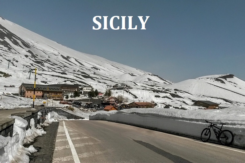
SICILY
Cycling routes by starting location:
All of the listed starting points can be reached by car with our own bike. If we decide to use public transport, we will find some information on the following pages:
The nearest airports to all routes in Sicily are Catania–Fontanarossa Airport (CTA) or Palermo Airport (PMO);
The choice of airport depends on where we want to fly from and on what day of the week. Details and proposals for connections from airports to "starting" locations can be found on the following pages describing each location, which we can select from the map below by clicking on the bike icon.
Suggestions for flights to Catania and Palermo can be found in the transport section.
CATANIA
To reach the town of Catania the fastest, we can arrive by plane at Catania–Fontanarossa Airport (CTA); information about arrivals at other airports and how to find a convenient flight, combined with railway and bus transport, can be found in the transport section;
One of the many ways to get to Catania is:
After arriving at Catania-Fontanarossa Airport, we head to the bus stop, where Interbus departs every 30 minutes towards Catania Via Archimede (Catania Centrale Station); the journey takes 10 minutes and the ticket price is 3-5€, the timetable can be found on the interbus.it website;
Information about public transport in Catania can be found on the amts.ct.it website;
Upon arrival in Catania using public transport, we reach the previously booked accommodation; good places to look for accommodation are trusted services such as airbnb.com and booking.com.
If we want to take advantage of the gastronomic offer, we can find the locations of gastronomic points on the mapy.cz website;
If we're not hungry, we don't waste time and head to the most important part of the program...
BiciTech road bike rental is located at: Via G. Terranova 6, 95131 Catania;
It's worth booking a bike well in advance to be sure of renting a bike upon arrival; current bike rental prices can be found on the rental website;
All proposed cycling routes (gpx tracks) from Catania start at Catania Centrale railway station or after arriving by train at the stations: Carruba, Fiumefreddo di Sicilia and Catenanuova-Centuripe;
If we arrived in Catania by car, we need to find a safe parking space.
Paid and free parking lots are shown on the
mapy.cz website;
More information about the town and its surroundings can be found on the comune.catania.it website.
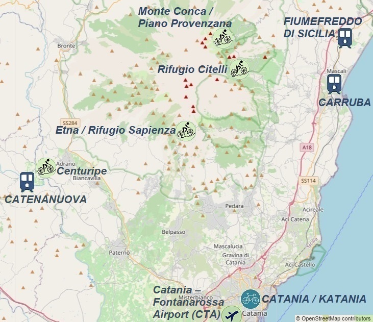
Hills accessible from Catania:
1. 62km - Etna / Rifugio Sapienza: 1908m
2. 84km - Monte Conca: 1810m
- Rifugio Citelli: 1736m
3. 90km - Centuripe: 694m
- Etna / Rifugio Sapienza: 1908m


GIARDINI NAXOS
To reach the town of Giardini Naxos quickly, the easiest way is to fly to Catania–Fontanarossa Airport (CTA); Information on flights to other airports and how to find affordable travel options, such as trains and buses, can be found under the transport section;
One of the many affordable options to get to Giardini Naxos is to take the Interbus, which departs every 30 minutes from the bus stop at:
Catania-Fontanarossa Airport towards Catania Via Archimede (Catania Centrale Station). The journey takes 10 minutes, and the ticket costs 3-5€. The timetable can be found on the interbus.it website;
From there, switch to a regional train and get off at Alcantara Station;
Once you arrive at Alcantara, you can take public transportation (the Giardini Naxos bus stop is located 100m south of the train station) or a taxi to get to your pre-booked accommodation. Good places to look for accommodation are trusted sites like airbnb.com and booking.com;
If you're looking for dining options, you can find restaurant locations on the mapy.cz website;
If we're not hungry, we don't waste time and head to the most important part of the program...
Cycling Sicily road bike rental is located at: Via Recanati 26, 98035 Giardini Naxos;
It's best to reserve a bike well in advance to ensure availability upon arrival. The current bike rental prices can be found on the rental company's website.
All proposed cycling routes (GPX tracks) from Giardini Naxos begin at the parking lot on Via Recanati or at the Novara-Montalbano-Furnari and Carruba train stations.
If you arrive in Giardini Naxos by car, you'll need to find a safe parking spot. Paid and free parking options are displayed on the
mapy.cz website;
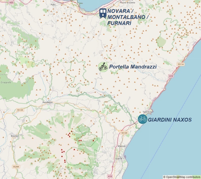
Hills accessible from Giardini Naxos:
1. 68km - Portella Mandrazzi: 1125m.a.s.l.
2. 86km - Etna / Rifugio Sapienza: 1908m.a.s.l.
- Monte Pomiciaro: 1468m.a.s.l.
3. 95km - Monte Conca: 1810m.a.s.l.
- Rifugio Citelli: 1741m.a.s.l.
4. 69km - Castelmola: 505m.a.s.l.
- Forza d'Agrò: 356m.a.s.l.
- Gallodoro: 388m.a.s.l.

CEFALÙ
To get to the town of Cefalù the fastest, we can fly to Aeroporto di Palermo (PMO); information on finding a favorable flight combined with rail and bus transportation can be found in the transport section;
Upon arrival at Palermo Airport, we head to the railway station: Stazione di Punta Raisi, from where a regional train to Palermo departs every 30 minutes, where we switch to a train to Cefalù; the entire journey takes 1h40min to 2h10min depending on the time of day; the ticket price is €12, and the timetable with the option to purchase a ticket can be found on the trenitalia.com section;
Upon arriving in Cefalù, using public transport or a taxi, we reach the previously reserved accommodation; good places to look for accommodation are the verified services: airbnb.com and booking.com;
If we want to take advantage of the gastronomic offer, we can find the locations of gastronomic points on the mapy.cz website;
If we are not hungry, we do not waste time and go to the most important point of the program...
Bikestation Kalura Sicily road bike rental is located at: Via Vincenzo Cavallaro 13, 90015 Cefalù;
it is worth reserving a bike well in advance to ensure renting a bike upon arrival; current rental prices can be found on the rental website;
all proposed cycling routes (gpx tracks) from the town of Cefalù start at Cefalù railway station or after arriving by train at the station;
If we have arrived in Cefalù by car, we must find a safe parking space. Paid and free parking lots are shown on the
mapy.cz website;
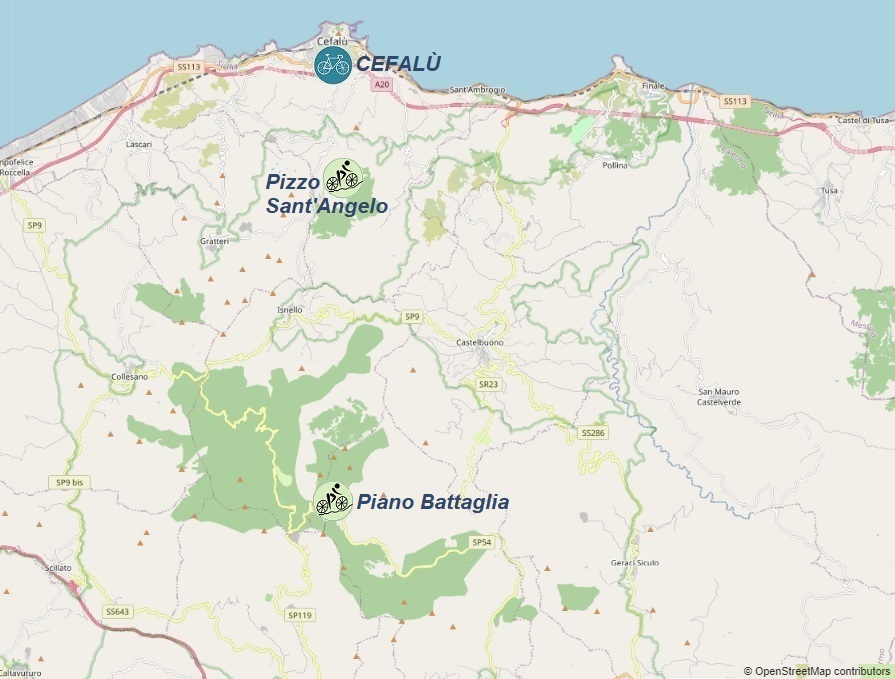
Hills accessible from Cefalù:
1. 108km - Piano Battaglia: 1648m.a.s.l.
- Pizzo Sant'Angelo: 994m.a.s.l.
2. 91km - San Mauro Castelverde: 1002m.a.s.l.
- Monte Pomiciaro: 1468m.a.s.l.
3. 66km - Pollina: 756m.a.s.l.
- Portella di Montenero: 307m.a.s.l.
4. 124km - Portella dell'Óbolo: 1503m.a.s.l.
- Sella del Contrasto: 1120m.a.s.l.
